No products
Product successfully added to your shopping cart
There are 0 items in your cart. There is 1 item in your cart.
Europe There are 39 products.
Subcategories

-
Antique map of Holland and Westfalia....
Antique map of Holland and Westfalia (Partie de L'Empire Français Royaume de Hollande Westphalie). Robert de Vaugondy (1806). An interesting map created by Robert de Vaugondy for the 'Atlas Universel' in 1757 and corrected by his successor Lamarche. The Atlas Universel is one of the most important 18th-century atlases. This impression is dated on 1806....
160 €Available -
Antique map of northern regions of...
Antique map of northern regions of Germany (Cercles de Haute Saxe et de Basse-Saxe). Robert de Vaugondy.. An interesting map created by Robert de Vaugondy for the 'Atlas Universel' in 1757 and corrected by his successor Lamarche. The Atlas Universel is one of the most important 18th-century atlases. Plate size: 25,6x32 cm. Paper size: 31,8x45 cm.
180 €Available -
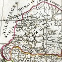
Antique map of Baviera and Austria. Robert...
Antique map of Baviera and Austria (Circles de Baviere et dAutriche). An interesting map created by Robert de Vaugondy for the 'Atlas Universel' in 1757 and corrected by his successor Lamarche. The Atlas Universel is one of the most important 18th-century atlases. This impression was published after the French Revolution and dated as year 3 in the French...
180 €Available -
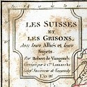
Antique map of Switzerland. Robert de...
Antique map of Switzerland (Les Suisses et les Grisons). Robert de Vaugondy (1794). An interesting map created by Robert de Vaugondy for the 'Atlas Universel' in 1757 and corrected by his successor Lamarche. The Atlas Universel is one of the most important 18th-century atlases. This impression was published shortly after the French Revolution and dated as...
160 €Available -
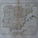
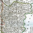
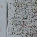
Antique map of Spain and Portugal. Robert...
Antique map of Spain and Portugal (Royaumes dEspagne et de Portugal). An interesting map created by Robert de Vaugondy for the 'Atlas Universel' in 1757 and corrected by his successor Lamarche. The Atlas Universel is one of the most important 18th-century atlases. This impression was published shortly after the French Revolution and dated as year 3 in the...
200 €Available -
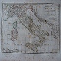
Antique map of Italy. Robert de Vaugondy...
Antique map of Italy (LItalie). Robert de Vaugondy (1794). An interesting map created by Robert de Vaugondy for the 'Atlas Universel' in 1757 and corrected by his successor Lamarche. The Atlas Universel is one of the most important 18th-century atlases. This impression was published shortly after the French Revolution and dated as year 3 in the French...
220 €Available -
Antique map of northern regions of Italy....
Antique map of northern regions of Italy. An interesting map created by Robert de Vaugondy for the 'Atlas Universel' in 1757 and corrected by his successor Lamarche. The Atlas Universel is one of the most important 18th-century atlases. This impression was published shortly after the French Revolution and dated as year 3 in the French Republican Calendar.
220 €Available -
Antique map of southern regions of Italy....
Antique map of southern regions of Italy (Royaume de Naples et de Sicile). Robert de Vaugondy. An interesting map created by Robert de Vaugondy for the 'Atlas Universel' in 1757 and corrected by his successor Lamarche. The Atlas Universel is one of the most important 18th-century atlases. Plate size: 25,8x30 cm. Paper size: 31,8x45 cm.
180 €Available -
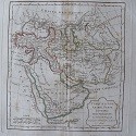
Antique map of Hungary and Turkey. Robert...
Antique map of Hungary and Turkey (Hongrie Turquie Europ). Robert de Vaugondy (1794). An interesting map created by Robert de Vaugondy for the 'Atlas Universel' in 1757 and corrected by his successor Lamarche. Plate size: 24,3x31 cm. Paper size: 31,8x45 cm.
180 €Available -
Charte vom Konigreich Württemberg Baden...
Engraving of Württemberg Baden edited in Augsburg by Joh Walch. Image measures 22x19 cm.
110 €Available -
Karte von dem Turkischenreiche in Europa...
Engraving of Turkey edited in Augsburg by Joh Walch. Measures 22x19 cm.
110 €Available -
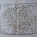
Karte des Europaeischen Russland edited in...
Russian engraving edited in Augsburg by Joh Walch. Measures 22x18 cm. Written in pencil on the reverse.
110 €Available -
Karte der Mark Branderburg Pommern edited...
Engraving of Brandenburg by Joh Walch. Measures 18.7x22 cm.
100 €Available -
Charte von Italien edited Augsburg by...
Engraving from Italy or Johannes Walch. Measures 22x19 cm.
120 €Available -
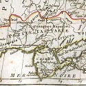
The Black Sea and surrounding countries
Old engraving of the Black Sea and surroundings. Measures 19x26 cm.
70 €Available -
Charte des Preussischen States edited in...
Engraving edited in Augsburg by Johannes Walch. Measures 18.3x22.5 cm.
100 €Available -
Charte vom Koenigreich Baiern Württemberg...
Engraving edited in Augsburg by Johannes Walch. Measures 18x22.5 cm.
100 €Available -
Charte von Oesterreich bei Joh Walch 1812
Engraving edited by Joahnnes Walch in Augsburg. Measures 19x23 cm.
100 €Available -
Carte de l'Espagne&de Portugal by Pieter...
Map of Spain and Portugal by Pieter Vander Aa under the pseudonym Alvarez de Comenar made in 1707 from the work Delices de l'Espagne. It comes from the work of Pieter van der Aa Delices de Espagne et Portugal, published in Leyden (Holland) 1707 is the most illustrated work on Spain published at the beginning of the eighteenth century. Image measures...
90 €Exhausted


