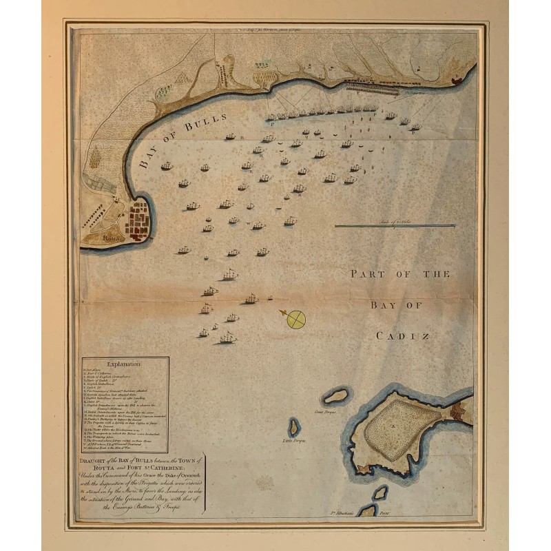


Original engraved map of the bay of Cadiz: a plan of the inlet the English sources call the Bay of Bulls, between the town of Rota and the fort of Santa Catalina, drawn to illustrate the Anglo-Dutch landing of August 1702, at the opening of the War of the Spanish Succession.
Original engraved map of the bay of Cadiz: a plan of the inlet the English sources call the Bay of Bulls, between the town of Rota and the fort of Santa Catalina, drawn to illustrate the Anglo-Dutch landing of August 1702, at the opening of the War of the Spanish Succession.
The expedition, under the Duke of Ormonde and Admiral Rooke, failed in its attempt to take Cadiz. The plan draws one by one the frigates anchored to cover the landing, the enemy batteries and troops and the lie of the ground, with an Explanation table of twenty entries and a scale in miles. Rota, the point of San Sebastian, El Puerco and El Perejil are lettered.
Medium: Copper engraving on laid paper, with period hand coloring.
Source: Published by Harrison, London. Engraved title at the foot: Draught of the Bay of Bulls between the Town of Rotta and Fort St. Catherine: Under the Command of his Grace the Duke of Ormond, with the disposition of the Frigats which were ordered to attend in by the Shore, to favor the Landing, as also the situation of the Ground and Bay, with that of the Enemys Batterys & Troops.
Dimensions: Image 17.5 x 14.3 in (44.5 x 36.4 cm).
Condition: Good overall. Two horizontal folds from the publisher's folding, visible against the light.
Original engraved map of the bay of Cadiz: a plan of the inlet the English sources call the Bay of Bulls, between the town of Rota and the fort of Santa Catalina, drawn to illustrate the Anglo-Dutch landing of August 1702, at the opening of the War of the Spanish Succession.