Norway and Kingdom of Denmark - Original Vaugondy Engraving - 1794-95
search
  • Norway and Kingdom of Denmark - Original Vaugondy Engraving - 1794-95
  • Norway and Kingdom of Denmark - Original Vaugondy Engraving - 1794-95
  • Norway and Kingdom of Denmark - Original Vaugondy Engraving - 1794-95

Norway and Kingdom of Denmark - Original Vaugondy Engraving - 1794-95

€140.00
Tax included
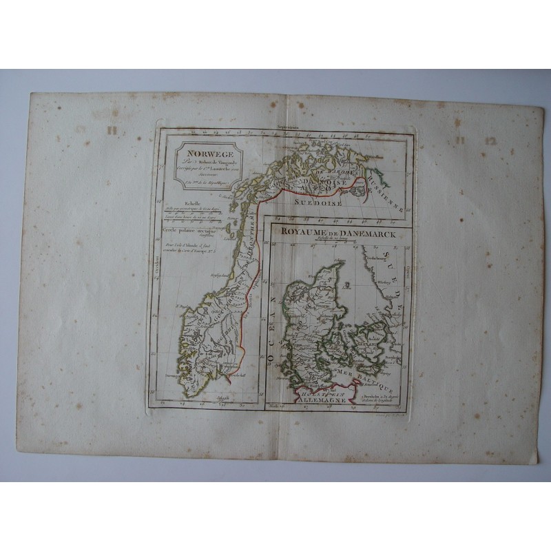
Antique map of Norway and Denmark (Norwege el Royaume de Danemarck). Robert de Vaugondy (1794). An interesting map created by Robert de Vaugondy for the 'Atlas Universel' in 1757 and corrected by his successor Lamarche. The Atlas Universel is one of the most important 18th-century atlases. This impression was published shortly after the French Revolution and dated as year 3 in the French Republican Calendar. Plate size: 25,4x30 cm. Paper size: 31,8x45 cm. Condition: Rust spots that can be seen in the image. Gilles Robert de Vaugondy (1688-1766) and his son, Didier Robert de Vaugondy (1723-1786), formed one of the most prominent and recognized map and globe-making workshops in France in the mid-18th century. They were descendants of one of the most important cartographers of the previous century, Nicolas Sanson through his grandson Pierre Moulard-Sanson, from whom in 1730 they inherited most of the cartographic material that the Sanson dynasty had accumulated over almost a century of work, material that they completed with the one acquired from the descendants of Hubert Jaillot. With them they formed the basis with which to start his most ambitious and well-known work, the Atlas Universel (1757), one of the most beautiful atlases produced by the French school in the middle of the century. To do this, the Vaugondys, who had excellent geographic training, integrated the information obtained from the review of the oldest inherited materials with the most up-to-date maps of the moment, including new place names, the latest academic research, the diaries of contemporary explorers and missionaries. and even astronomical observation, sometimes checking and correcting the latitude and longitude of many maps from their own observations. In addition, unlike many cartographers of the time, they made an effort to indicate the sources they used to elaborate them, just as at the time such prominent cartographers as Ortelius or Mercator did. Both worked together and, sometimes, it is not possible to attribute their maps to the father or the son, since they often signed with the last name, without the initials, although in other cases the authorship can be determined by the distinctive shape of each: the father normally uses "M. Robert" and son "Robert de Vaugondy." Both received the honorary title of Geographe ordinaire du Roy, the father in 1730 and Didier in 1760. On the son's death, the cartographic workshop passed to Jean Fortin monkeys, in 1778, and later to Charles Francis Delamarche.
Quantity
In Stock

Original map of Norway ("Norwege"), with an inset of the Kingdom of Denmark ("Royaume de Danemarck"), engraved on copper with hand-coloured outlines, from the work of Robert de Vaugondy. According to the cartouche, it was corrected by Citizen Lamarche, his successor, in Year III of the French Republic (1794-1795). A note refers to the map of Europe no. 5 for Iceland.

Gilles and Didier Robert de Vaugondy, father and son, were renowned eighteenth-century cartographers, descendants of the cartographer Nicolas Sanson, from whom they inherited much of their cartographic material. In 1757 they published their most famous work, the Atlas Universel, and in 1760 Didier Robert de Vaugondy was appointed geographer to Louis XV. Their successor Charles-François Delamarche later revised and corrected the plates.

Medium: Copper engraving (intaglio) on paper, with hand-coloured outlines.
Artist / after: Robert de Vaugondy; corrected by Citizen Lamarche, his successor.
Date: Year III of the French Republic (1794-1795), as stated in the cartouche.
Dimensions: Plate 10.0 x 11.8 in (25.4 x 30 cm); sheet 12.5 x 17.7 in (31.8 x 45 cm).
Condition: Age foxing scattered across the margins and, to a lesser extent, the map, with a few small dark spots at the left; handwritten numbers "11" and "12" in the upper margin, with their offset on the other side; original central fold; wide margins.

10087